Natural and the Built Environments
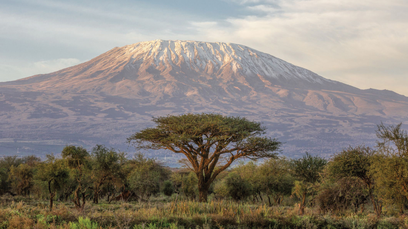
- What can you see in picture (a)?
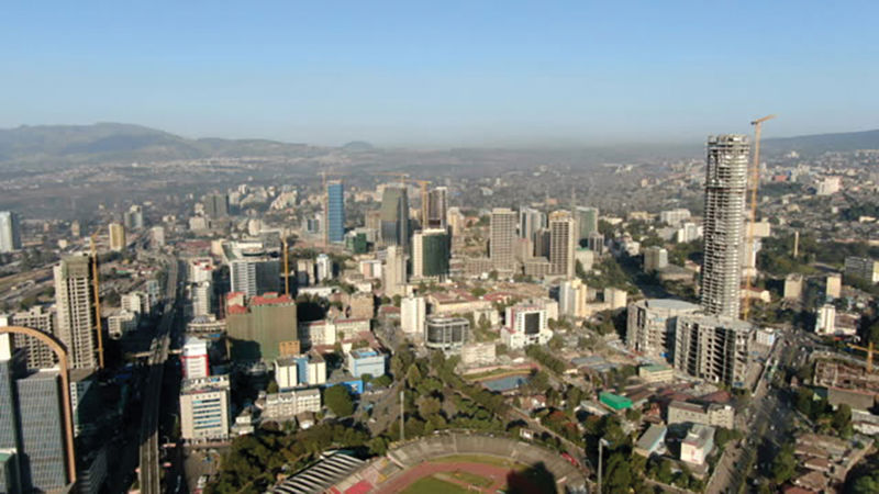
- What can you see in picture (b)?
Key points
Picture (a) shows Mt. Kilimanjaro. This is an example of natural environment. Picture (b) shows a section of the city of Addis Ababa in Ethiopia. This is an example of built environment.
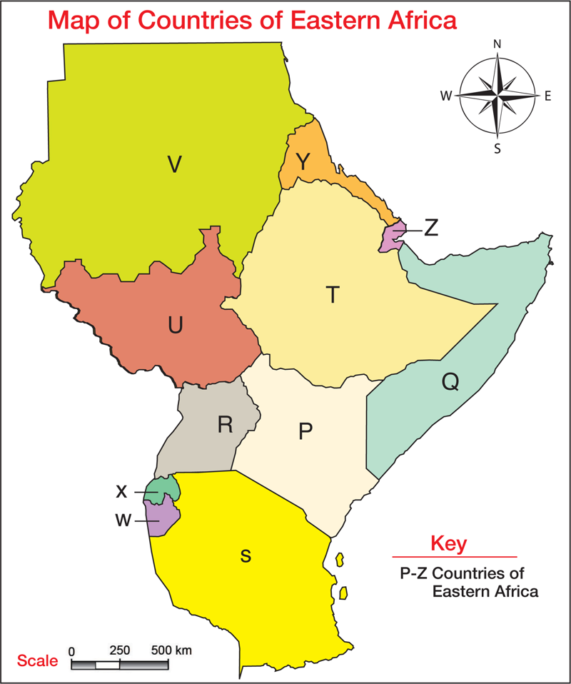
Countries of Eastern Africa
- Look at the Map of Countries of Eastern Africa.
- Using digital devices, atlas or other resources, identify the countries labelled P, Q, R, S, T, U, V, W, X, Y and Z.
- Write the names of the countries labelled P–Z from the map.
- Share your findings in class.
Key point
The countries of Eastern Africa are: Kenya, Uganda, Sudan, Burundi, Somalia, South Sudan, Djibouti, Rwanda, Eritrea, Tanzania and Ethiopia.
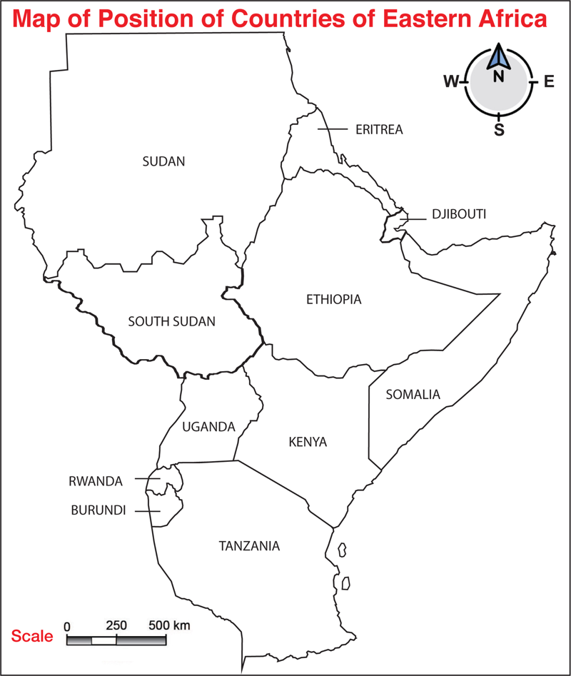
Position of Countries of Eastern Africa
Each of the countries of Eastern Africa occupies a specific position in the region.
- Study the Map of Position of Countries of Eastern Africa.
- Using the map, atlas, digital devices or other resources, locate the position of each of the countries of Eastern Africa.
Country | Position |
Sudan | |
Eritrea | |
South Sudan | |
Djibouti | |
Ethiopia | |
Uganda | |
Kenya | |
Somalia | |
Tanzania | |
Rwanda | |
Burundi |
- Share your findings in class.
Work with your parent or guardian
- Describe the position of the countries of Eastern Africa from your home.
- Compare your findings in class.
Key points
We can locate the position of a country in relation to her neighbours by use of a compass direction. For example, Kenya lies to the North East of Tanzania, South of Ethiopia, South East of South Sudan, East of Uganda and West of Somalia.
Ethiopia lies to the North of Kenya, East of South Sudan, South of Eritrea, South East of Sudan and West of Somalia.
The immediate neighbours of Kenya are Tanzania, Uganda, South Sudan, Ethiopia and Somalia.
Sizes of Countries of Eastern Africa
- Using digital devices, atlases or other resources, find out the sizes in square kilometres of countries of Eastern Africa.
- Complete the following table on sizes of countries of Eastern Africa.
No. | Country | Size in square kilometres (km2) |
(a) | Kenya | 580,367 km2 |
(b) | Uganda | 241,037 km2 |
(c) | Eritrea | km2 |
(d) | Tanzania | km2 |
(e) | Somalia | km2 |
(f) | Sudan | km2 |
(g) | South Sudan | km2 |
(h) | Djibouti | km2 |
(i) | Burundi | km2 |
(j) | Rwanda | km2 |
(k) | Ethiopia | km2 |
- Share with the rest of the class.
Key points
The largest country in Eastern Africa is Sudan while the smallest country is Djibouti.
Activity 6: Individual work
- Draw the map showing countries of Eastern Africa.
- Colour or paint all the countries of Eastern Africa using different colours.
- Display the map you have drawn in class.
Activity 7: Group work
Fun zone
- Go outside the classroom and make a circle.
- Place a map showing countries of Eastern Africa in the middle.
- Throw a coin on the map at intervals and describe the position and size of the country where the coin has landed.
- Let every learner throw the coin and say the position and size of countries in Eastern Africa.