Natural and Built Environments. Position and Size of Countries in Eastern Africa

Get ready to learn about

  1. Countries of Eastern Africa.
  2. Positions and sizes of countries in Eastern Africa.
  3. Locating places on a map using latitudes and longitudes.
  4. The unity of Eastern African countries.

Eastern Africa is one of the five regions in Africa. It is made up of several countries with different sizes and are located at different places.
Countries of Eastern Africa

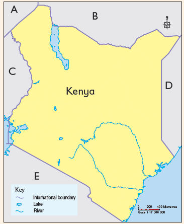
Map of Kenya
  1. Use an atlas or wall map to find out information about the countries that make up Eastern Africa.
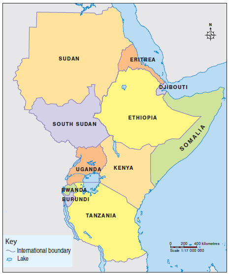
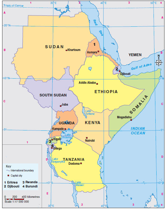
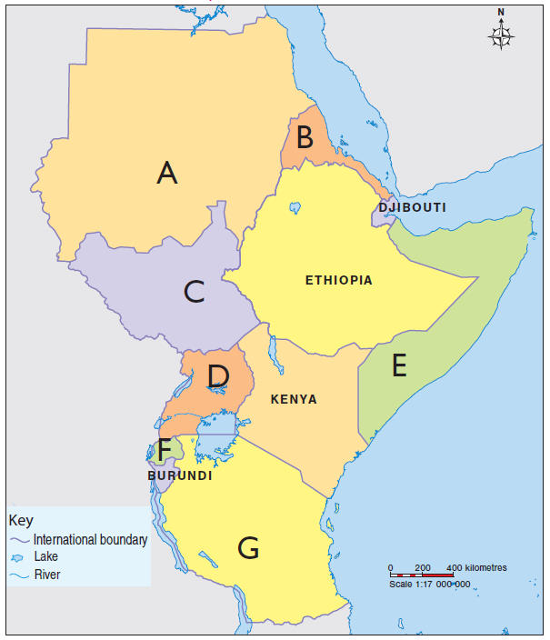
  2. Study the map of Eastern Africa and answer the questions that follow.
    1. Select the names of the countries marked A, B, C, D, E, F and G.
    2. Share the names of the countries found in Eastern Africa.
  3. Study the names of countries.
    1. Mark (✔) to show the countries that are found in Eastern Africa. Do not mark those that are not.
    2. Share your answers in class.
  • Kenya
  • Egypt
  • Zambia
  • Tanzania
  • Rwanda
  • Burundi
  • South Sudan
  • Ethiopia
  • Sudan
  • Eritrea
  • Somalia
  • Djibouti
  • Uganda
  • Nigeria
  • Senegal
    1. Draw a map of Eastern Africa on a piece of paper and show the countries that are found in Eastern Africa.
    2. Display your map in class.
    3. Use your map to do a presentation on the countries of Eastern Africa.
Map of Eastern Africa

Learning zone

Eastern Africa is a region located in the Eastern region of Africa.

It is made up of eleven independent countries namely:

  1. Sudan
  2. Ethiopia
  3. Tanzania
  4. Somalia
  5. South Sudan
  6. Kenya
  7. Uganda
  8. Eritrea
  9. Burundi
  10. Rwanda
  11. Djibouti

Extended activity

  1. Use locally available materials to model a map of Eastern Africa.
  2. Share your model in class.

Position and size of countries in Eastern Africa

  1. Share the names of countries in Eastern Africa. 
  2. Which country is found to the West of Kenya?
  3. Which country is found to the East of Kenya?
  4. Select the smallest country in Eastern Africa.
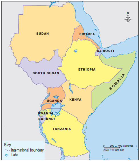
  1. Study the map and use it to solve the riddles that follow.
    1. I am bordered by Kenya to the east, Tanzania to the south, and South Sudan to the north.
      Which country am I?
    2. I am a country located to the south of Kenya.
      Which country am I?
    3. I share borders with Kenya and Eritrea.
      Which country am I?
    4. I am located to the east of Kenya.
      Which country am I?
    5. I border Kenya to the northwest.
      Which country am I?
  2. Share your answers in class.
  3. As a class, play the game “Position of countries in Eastern Africa”.
    1. Draw a map of Eastern Africa on the board or use a wall map showing the countries.
    2. Choose a game leader to lead in the game.
    3. The game leader to point at the countries on the map, one by one. The rest of the class to answer the following questions about the pointed country.
      1. Which countries neighbour it?
      2. In which directions are the neighbouring countries in relation to the pointed country?
Map of Eastern Africa

Learning zone

Eastern Africa is made up of countries that are located in different parts of the region.
​The countries have their neighbours which help in finding their positions.

Size of countries in Eastern Africa

  1. Study the map of Eastern Africa and answer the questions that follow.
    1. Which is the largest country in Eastern Africa?
    2. Which is the smallest country in Eastern Africa?
    3. Select the countries that are bigger than Kenya.
  • Tanzania
  • Uganda
  • Rwanda
  • Djibouti
  • Ethiopia
  • Burundi
  • Somalia
  • Eritrea
  • South Sudan
  • Sudan
  1. d) Select the countries that are smaller than Kenya.
  • Tanzania
  • Uganda
  • Rwanda
  • Djibouti
  • Ethiopia
  • Burundi
  • Somalia
  • Eritrea
  • South Sudan
  • Sudan
    1. Use a textbook or digital device to search for information about the sizes of countries in Eastern Africa in square kilometres.
    2. Share your findings in class.
    1. Draw a map of Eastern Africa on a piece of paper.
    2. Display your map.
    3. Use your map to make a presentation in class on the sizes of countries of Eastern Africa.
  1. Select the appropriate sizes of the countries of Eastern Africa.
    1. Sudan
    2. Ethiopia
    3. Tanzania
    4. Somalia
    5. South Sudan
    6. Kenya
    7. Uganda
    8. Eritrea
    9. Burundi
    10. Rwanda
    11. Djibouti
Map of Eastern Africa

Extended activity

In groups, do the following:

  1. Draw a sketch map of Eastern Africa on a manila paper or cardboard.
  2. ​Cut out the individual countries in Eastern Africa from the sketch map you have drawn.
  3. Write the names of countries of Eastern Africa.
  4. Let the group leader use the cut-out maps to ask the following questions. Pick the correct map of the country to answer the questions.
    1. ​Name the neighbours of the country.
    2. In which part of Eastern Africa is the country found?
  5. Continue asking questions in turns until all the countries are talked about.

Learning zone

  • The largest country in Eastern Africa is Sudan.
  • The smallest country in Eastern Africa is Djibouti.

The following list shows the sizes of the countries in Eastern Africa in square kilometres.

  1. Sudan – 1.886 million km2
  2. Ethiopia – 1.104 million km2
  3. Tanzania – 945 087 km2
  4. Somalia – 637 655 km2
  5. South Sudan – 644 329 km2
  6. Kenya – 580 367 km2
  7. Uganda – 241 037 km2
  8. Eritrea – 117 598 km2
  9. Burundi – 27 834 km2
  10. Rwanda – 26 338 km2
  11. Djibouti – 23 200 km2

Using latitudes and longitudes to locate places on a map

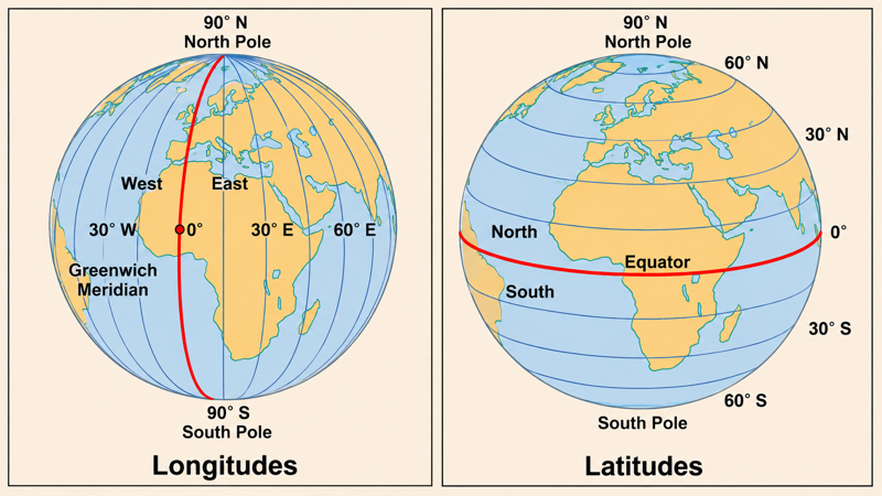
Latitudes are imaginary lines on the earth’s surface that run from West to East. They run horizontally across maps.
Longitudes are imaginary lines that run from North to South.

  1. Study the diagrams and find the lines of latitudes and longitudes.
  2. Select the statements that show the differences between latitudes and longitudes as shown in the diagrams.
  • Latitude are imaginary lines that run west–east while longitudes are imaginary lines that run north–south.
  • Latitude are imaginary lines that run north–south while longitudes are imaginary lines that run east–west.
  • Latitude are imaginary lines that run east–west while longitudes are imaginary lines that run south–north.
  • Latitudes measure distance north or south of the Equator while longitudes measure distance east or west of the Prime Meridian.
  • Latitudes are parallel to each other and never meet while Longitudes converge (meet) at the North and South Poles.
    1. Use textbooks or digital devices to:
      1. Find out the differences between latitudes and longitudes.
      2. Identify how to locate places on a map using latitudes and longitudes.
    2. Share your findings in class.
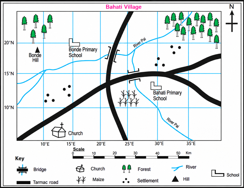
  1. Use the sketch map of Bahati village and the steps that follow to locate Bonde Primary School.
    1. Find the place to be located on the map. In this case, it is Bonde Primary School.
    2. Find the line of longitude which passes through that particular place. In this case, 15°E.
    3. Find the line of latitude which passes through that particular place. In this case, 20˚N.
    4. Write the two values together, starting with the value of longitude followed by the value of latitude. In this case, 15˚E, 20˚N.
    5. Therefore, the location of Bonde Primary School is 15˚E, 20˚N.
  2. Use the steps to locate the following:
    1. Bonde Hill
    2. Church
  3. Study the map of Eastern Africa. Find the locations of:
    1. Kilimanjaro
    2. Nairobi
    3. Khartoum
    4. Lake Malawi
    1. Select the names of the cities located in the following lines of latitudes and longitudes.
      1. 39˚E, 15˚N
      2. 32˚E, 15˚N
      3. 42˚E, 11˚N
      4. 41˚E, 1˚N
      5. 38˚E, 8˚N
    2. Share your answers in class.
Map of Eastern Africa

Learning zone

Longitudes measure how far East or West a place is from the prime meridian which is on longitude. Latitudes measure how far North or South a place is from the Equator which is on latitude.

The following are the steps followed when locating the latitude and longitude of a place.

  1. Find the place to be located on the map.
  2. Find the line of longitude which passes through that particular place.
  3. Find the line of latitude which passes through that particular place.
  4. Write the two values together, starting with the value of longitude followed by the value of latitude.

Digital zone

  1. Use a digital device to find the location of the following places.
    1. Nairobi
    2. Lake Victoria
    3. Mount Kenya
  1. Share your answers in class.

The unity of Eastern African countries

Think and share

  1. The Eastern African countries share borders with one another.
  2. The citizens of the countries live in unity.
  3. Share the things that unite the people of Eastern Africa.
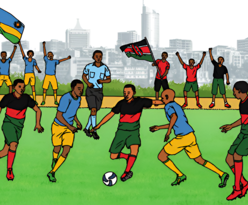
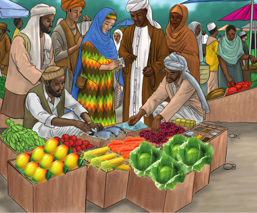
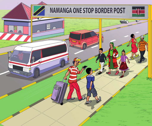
  1. Study the pictures and talk about the things that unite the countries of Eastern Africa.
    1. Select True for statements that show the benefits of unity among Eastern African countries and False for those that do not.
      1. Enhanced economic cooperation and trade.
      2. Increased regional conflicts and disputes.
      3. Improved infrastructure development across borders.
      4. Cultural exchange and mutual understanding among the populations.
      5. Restriction of movement and trade among countries.
      6. Joint efforts in addressing common challenges such as climate change and security threats.
      7. Wasting resources and efforts, making things less efficient.
      8. Enhanced tourism through shared marketing of regional attractions.
    2. Share your work in class.
    1. Compose a poem about unity of Eastern Africa.
    2. Recite the poem in class.
East African Football match
Trade among Eastern Africa citizens
Crossing at Namanga border between Kenya and Tanzania
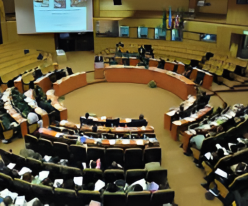
East Africa Legislative Parliament

Learning zone

The Eastern African countries are united through the following ways:

  1. Participating in sports.
  2. Engaging in trading activities.
  3. Having common symbols of unity such as an anthem.
  4. Having common languages in the region, for example, English and Kiswahili.
  5. Allowing free border movements and trade.
  6. Having joint security efforts to combart conflict, for example, Somalia.

Focus on Eastern Africa

Share things that unite the Eastern African people.

Sing the East African Community anthem. Use the lyrics given.

East African Community Anthem

  1. Ee Mungu twaomba ulinde
    ​Jumuiya Afrika Mashariki
    ​Tuwezeshe kuishi kwa amani
    ​Tutimize na malengo yetu.

    ​​Chorus
    ​Jumuiya Yetu sote tuilinde
    ​Tuwajibike tuimarike
    ​Umoja wetu ni nguzo yetu
    ​Idumu Jumuiya yetu.
  2. Uzalendo pia mshikamano
    ​Viwe msingi wa Umoja wetu
    ​Natulinde Uhuru na Amani
    ​Mila zetu na desturi zetu.
  3. Viwandani na hata mashambani
    ​Tufanye kazi sote kwa makini
    ​Tujitoe kwa hali na mali
    ​Tuijenge Jumuiya bora.

Assessment task

Skills

Correctly

When assisted

  1. I can identify the countries of Eastern Africa on a map.
  1. I can describe the positions and sizes of countries in Eastern Africa.
  1. I can use latitudes and longitudes to locate places on a map.
  1. I appreciate the unity of Eastern African countries.